Did you know that the Delaware border has an arc?!

No, I’m not talking about a large wooden ship said to have carried pairs of animals to safety from an epic flood.
I’m referring to Delaware’s 12-mile circle — the large, curved border that divides Delaware from neighboring Pennsylvania.
Delaware is the only state in the entire United States that has an almost perfectly circular arc or circle for a border.
This unusual state border has a fascinating history and is a favorite destination for Civil War fans, Americana enthusiasts, and those who love maps and cartographic history.
Fun Facts About Delaware & The 12-Mile Circle Arc
I’ve been intrigued by the outline of Delaware’s border since I was a kid. Namely, why is the top of the state circular, like an arc?
Land deals and legal conflicts have muddied the exact location of Delaware’s border for centuries, and the Delaware arc is part of that mapping melee.

The Delaware state boundaries roughly consist of:
- An east-west border along the south
- A seemingly north-south boundary along the west
- The circular arc at the top of the state
- The Delaware River, Delaware Bay, and Atlantic Ocean on the east
However, the arc doesn’t really form a perfect circle, and the other boundaries have been contested in courts and among legal and cartographic scholars seemingly forever:
- The state of Delaware was first referenced in 1682 when it was gifted from King Charles II to his brother James Duke of York.
- James turned around and gifted Delaware to William Penn to help repay a royal family debt to his father.
- Penn wanted land adjacent to his charter to grant him access to the Atlantic Ocean, but James didn’t like the idea of him getting any ideas on overtaking New Castle. So he drew a radial line around the town.
- That radius measures 12 miles from the cupola atop the New Castle Court House in northern Delaware and defines the northern boundary of Delaware bordering Pennsylvania.
- The Delaware arc was extremely difficult to chart and is composed of various radii, thus it’s not a perfect circle.
- Meanwhile, boundary disputes and some minor imperfections with geographical charting at the time created a triangular wedge of land about a square mile in size and officially recognized as belonging to Delaware since 1921.
Believe it or not, the Delaware arc facts above barely skim the surface of the amazing history behind the land disputes and other colorful backstory behind the state’s unusual border!
Where Is The Mason-Dixon Line In Delaware?
Land disputes involving Delaware, Pennsylvania, and Maryland during the 1760s led to famous land surveyors Charles Mason and Jeremiah Dixon to define the dividing boundary of the three neighboring states.
This line forms the northern border of Maryland and southern border of Pennsylvania as well as the eastern boundary of Maryland and western line of Delaware.
The Mason-Dixon Line became important for helping define the “North” (Union territory) from the “South” (Confederate territory) during the Civil War. Today, it has mainly sociopolitical implications and is a popular for culturally dividing the Northeast and the South.
I’m always amazed at how different life is on each side of the Mason-Dixon Line… It’s almost like two Americas.
When I’m driving up and down the I-95 corridor on my road trips to Delaware and points north or south, I really do see and feel some palpable cultural differences on either side of the Mason-Dixon Line. Politics change, accents change, and even the cuisine changes from one side of the Mason-Dixon Line and the other!
It’s kinda neat to be in Delaware, which is east of the Mason-Dixon Line — a spot not often referenced when talking about this famous north-south boundary.
What It’s Like Visiting The Delaware Arc Corner Monument
My wife and I were on one of our trips to Delaware when we decided to see the Delaware Arc Corner Monument that defines the bottom of Delaware’s arc — where it meets the northeastern tip of the wedge.
This marker is located along a trail between White Clay Creek Preserve and White Clay Creek State Park — a scenic Delaware state park near the college town of Newark, where the University of Delaware is located.

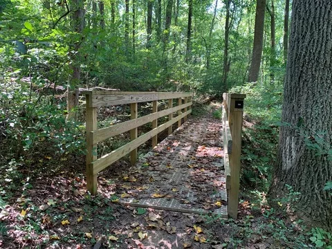
We parked our car near the Chambers House Nature Center in Newark, Delaware — and proceeded to a trail that intersects with Hopkins Bridge Road:

The trail we took is a bit rugged, but very scenic. This footbridge crosses a creek that winds throughout the park:
Finally, we spotted a clearing where the Delaware Arc Corner Monument stands:

Here’s the top of the Delaware Arc Corner Monument — clearly defining the corner of the arc and indicating the top of the wedge. I took this photo standing in Delaware. On the other side of this monument is Pennsylvania:

There are other monuments in the vicinity that pay homage to the wedge in Delaware as well as the Mason-Dixon Line.
As the Delaware arc constitutes the state’s entire northern border, you can encounter the arc pretty much along any drive that takes you between Delaware and Pennsylvania.
What makes the Delaware Arc Corner Monument unique is that it is a survey marker that both defines a single important point along the arc and is easily accessible to the public!
My wife and I reached the arc monument via trail from White Clay Creek State Park, but there are many folks who reach this point from the Pennsylvania side by way of White Clay Creek Preserve.
The Delaware wedge and Mason-Dixon Line monuments are located not far away but are tricky to get to because much of the surrounding terrain is private property — and you don’t want to trespass on people’s yards to reach these monuments.
Last but not least, there is the Tri-State Monument. This is where you can essentially stand in 3 states at once: Delaware, Maryland, and Pennsylvania.
I think one of the neatest things about checking out these monuments, aside from the history they represent, is how accurate these markers are given when they were erected. They’re a real testament to the surveyors of yore who, before computers and GPS, managed to map out these United States!